Situation in Bihar to worsen after heavy rainfall in Nepal

Source: indiatoday.in

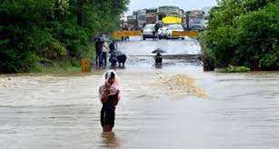
The flood situation in Bihar remained grim on Wednesday and is expected to worsen as neighbouring Nepal is witnessing heavy rainfall and the water from the overflowing rivers there may flow in to Bihar, an official said.

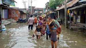
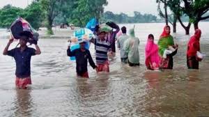
So far, 106 people have died while over eight million have been affected by the floods in Bihar. Thousands have been displaced across the state’s 12 districts as rivers are flowing above the danger mark at several places, officials said.

An official from the Water Resources Department said that heavy rainfall in Nepal since Monday is bound to worsen the situation in Bihar.

Latest reports suggest that the water level in major rivers is continuing to rise and embankments have been breached at several places. Water is also spreading to new areas, forcing people to take shelter at safer places, officials said.

Bihar Water Resources Minister Sanjay Jha told the media that embankments were breached at several places due to heavy rainfall. “We are working to repair embankments,” he said.

Jha said the government is doing everything possible to help the flood victims.

According to Wednesday’s report on the website of the Disaster Management Department, more than eight million people living in 1,238 panchayats in 12 districts have been affected by the floods that were caused by heavy rain in north Bihar and the catchment areas of major rivers in neighbouring Nepal.

Taking serious note of the flood situation, Chief Minister Nitish Kumar has directed the airdropping of relief, particularly food packets, in the affected districts.

Opposition legislators have been raising the issue of the failure of the state government to protect embankments and to carry out adequate rescue and relief operations.

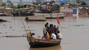
The Disaster Management Department said relief and rescue operations were continuing in the flood-affected areas. A total of 26 companies of the National Disaster Response Force, the State Disaster Response Force and the Seema Sashatra Bal have been deployed in the affected districts to carry out rescue operations.

Heavy Rainfall in Bihar; Rivers Pose Flood Threat to Many Districts

Source: weather.com

Ever since the monsoon swept the Bihar on June 22, the state has witnessed good rainfall. Bihar has received 333 mm of rainfall this season from June 1 to July 12— 9% more than normal for this time of the year. On Friday, the monsoon fury continued as many parts of the state were lashed with very heavy rainfall and thunderstorm.

The downpour is triggered by the monsoon trough—an extended region of low atmospheric pressure— that persists from east to west of Indo-Gangetic plain. This well-marked low-pressure has moved northwards since Thursday and a branch of it runs from northwest Bihar to northeast Bay of Bengal across Jharkhand and Gangetic West Bengal causing widespread rainfall throughout the region.

The Weather Channel met team has forecast the surface low-pressure to persist for the next 5 days leading to very heavy rain and thunderstorms across the region. The India Meteorological Department (IMD) has forecast heavy to very heavy rains with extremely heavy falls at isolated places across Bihar. The very heavy rainfall is very likely to continue in the state till Monday.

Water levels in all major rivers of north Bihar are rising due to the incessant rainfall in Bihar and Nepal. The Times of India reported that the river Gandak poses a flood threat to Muzzafarnagar and Champaran. The sorrow of Bihar, Kosi river, as well as other rivers like Karcha and Bagmati, are also likely to swell due to heavy rains. The authorities have been monitoring the situation.

The 24-hour rainfall accumulation in Patna till Friday morning was 25 mm. The temperatures in the city stayed 2°C below normal between 25°C and 31°C. Generally cloudy sky with intermittent rain is forecast in Patna till next Tuesday. More rains are likely to follow in the next week. The 24-hour rainfall was very high at 152 mm in Farbesgang and 130 mm Chapra.

Moderate to heavy rainfall in past 24 hours in Bihar

Source: newsonair.com

In Bihar, moderate to heavy rainfall occurred in western and eastern parts of the state in past 24 hours. 

Due to incessant rainfall in the catchment area of Nepal originating rivers for the last four days, Gandak, Bagmati and Budhi Gandak and their tributaries are swollen. 

Evacuation drive has been started in West Champaran from low-lying and riverine area of Gandak to shift people to safer places. 

East Champaran and Muzaffarpur. Traffic has been disrupted due to water-logging of Bagmati and Lalbakeya river on Sheohar-Motihari road. 

Extra vigil is being maintained on barrages, embankment and riverine area of Gandak, Budhi Gandak and Bagmati by engineers of water resource department. 

Flood relief & rescue teams have been put on standby by the Disaster Management Department. 

Heavy rains in Maharashtra’s Palghar district have disrupted traffic movement from Mokadha to neighbouring Nashik district. 

According to the Chief of Disaster Management Cell Vivekananda Kadam, a major portion of a bridge on a small river at Morchundi village washed away this morning. While no casualty has been reported, incidents of rainwater gushing inside villagers’ homes have come to light.

Bihar seeks to redefine danger levels in its rivers

Source: hindustantimes.com

After a long time, the Bihar government is going to undertake a massive exercise to revise the danger mark level of all major rivers in the state to make flood-fighting work more effective and reduce chances of false alarm of impending floods in case of rivers in spate in flood-prone districts.

The Bihar State Disaster Management Authority has recommended the idea of redefining the danger level of all major as well as small rivers after a study done on the subject over the last one year.

Experts said the primary reason for revising the danger level of rivers in the state is siltation that has caused the river beds to rise, a reason why the current danger level of rivers measured decades back are not so accurate.

“As the river bed of all majority of rivers has risen over the past many decades due to siltation, the danger level indicators are not so accurate. It often leads to false alarm of impending floods when in reality the river is flowing much below the danger mark. So, a reassessment of the danger level of major rivers is imperative,” said Vyasji, vice-chairman of the state’s disaster management authority.

In Bihar, there are 12 major river basins, including Ganga, Mahananda, Kosi, Bagmati, Sone, Karamnasa, Kamla, Chandan and Gandak, besides a large number of small rivers and their tributaries.

Sources said the state’s disaster management authority had already directed the water resources department and written to the Central Water Commission ( CWC) to start the work, which is going to be a time-consuming exercise. Sources said the government had been given the time to complete the exercise in next couple of months so that the new system comes in place before the rivers go in spate in the state.

The gauge readings of rivers is different from one point to another.

Like in Patna district, the Ganga’s gauge reading is different at Hatihdha , Gandhi ghat and Digha, said Vyasji.

To elaborate, the highest flood level( HFL) of Ganga in Patna was 50.27 metres but was revised to 50.52 metres in 2016.

“The gauge readings are different at many points of rivers and it has to be examined based on different parameters. Besides, the siltation of the rivers will be also taken into account in assessing the danger mark,” he said.

Ganga and Kosi are the major rivers in the state facing heavy siltation and efforts have been made to reduce the sedimentation to lower the river bed.

Kosi deluge in 2008 was one of the worst disasters in the state’s flood history in recent decades. Various studies on river management have put emphasis on regular dredging to reduce the siltation and check floods.

Besides, the disaster management authority also believes the revision of danger mark level of all major rivers, including where barrages have come up, would help check instances of false alarm of floods.

Officials said the water resources department, the parent department responsible for flood management, would be able to make proper flood management plan in advance based on accurate data once the revision is done.

“Whenever a river gets swollen either due to heavy rains or heavy discharge from upstream, panic grips people residing nears the rivers and the administration also starts gearing up resources for flood fighting. But in reality, such alarms are false many a time. So a revision of danger mark of rivers is need of the hour,” said Vyasji.